
Shortlist from Station Catalogue over facilities and science disciplines.

Collaborator in the project until spring 2022
STATION NAME AND OWNER
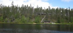
Mukhrino Field Station (https://mukhrinostation.com) was established as a part of the UNESCO chair Environmental dynamics and global climate change (EDCC) of Yugra State University in 2009.
LOCATION
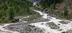
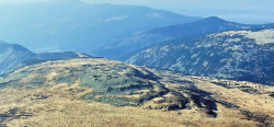
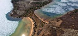
Mukhrino Field Station is located in the central part of West Siberia, middle taigaBoreal forest, a nearly continuous belt of coniferous trees across North America and Eurasia. Taiga is dense forest with many fallen trees and marshy soil. The term derives form the southern Siberian Turkic-Mongol... More biogeographic zone, 30 km to the south-west from Khanty-Mansiysk, on the left Irtysh River bank near the peatlandPeat is a soil type formed from slowly decomposing vegetation. It is found in wet areas where the lack of oxygen slows the breakdown of plant matter. Peatlands are areas... More Mukhrino. Geographic coordinates: 60.8889N, 68.7026E (https://goo.gl/maps/SHfW6LHgb6Q2).
BIODIVERSITY AND NATURAL ENVIRONMENT
Due to the severe continental climateThe average weather we would expect over a long period of time (seasons, years, decades). Climate varies from place-to-place across the Earth. Climate is determined by long-term (over at least... More, the environmental conditions in the regiona are comparable with the sub-arctic zone of Northern Europe. The research site is representative for the Western Siberian pristine carbon accumulating peatlandPeat is a soil type formed from slowly decomposing vegetation. It is found in wet areas where the lack of oxygen slows the breakdown of plant matter. Peatlands are areas... More ecosystemAll the living organisms (including people) in an area as well as its physical environment, functioning together as a unit. An ecosystem is made up of plants, animals, microorganisms, soil,... More (plain mires). The mires cover c. 60 % of the land surface and can be regarded as important sources/sinks of greenhouse gases and aerosols. The main mire type of the site is raised bogs of the type “Pine-dwarf shrubs-Sphagnum” (“ryam”) characterised by pine trees, Ledum palustre and other dwarf shrubs with dominating Sphagnum fuscum. Interspersed are mires of the type “Graminoid-Sphagnum type” dominated by Carex limosa, Scheuchzeria palustris and other graminoids, and Sphagnum balticum. Also ridge-hollow complexes, consisting of bog ridges and sphagnum lawns are present.
HISTORY AND FACILITIES
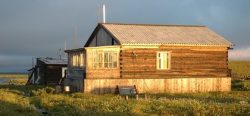
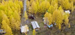
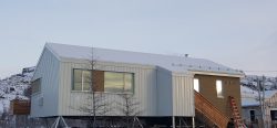
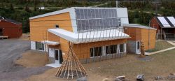
Mukhrino Field Station was established in 2009. It is equipped with modern facilities allowing conducting year-round long-term scientific research, scientific excursions, workshops, symposia and other events at national and international level. It has a two-storey wooden building with study/laboratory rooms, beds for 14 persons, a simple dining room with kitchen, and a Russian sauna. The experimental field is equipped with 1.5 km long walking boards, which cross the main mire ecosystemAll the living organisms (including people) in an area as well as its physical environment, functioning together as a unit. An ecosystem is made up of plants, animals, microorganisms, soil,... More types and facilitate researcher’s access to perform experiments and measurements in and above the mires, without disturbing the ecosystems. In the centre of the field site, an equipment shelter has been built. Distributed across the field site are clusters of thermologgers, water level recorders, automatic chambers for measurements of greenhouse gasA gas found in the earth's atmosphere that traps heat radiated from the surface of the earth, and causes the earth's temperature to rise. The term comes from the fact... More fluxes and Eddy Covariance tower for measurements of CH4 and CO2.
GENERAL RESEARCH AND DATABASES
The station was primarily established for studies of the biodiversityBiological diversity. The many and varied forms of life on Earth (collectively known as biota). As well as diversity of species (species diversity), there is also diversity within populations of a... More (faunaThe animals that live in a particular region, habitat or time (such as geological period like the jurassic). For plants, we use the term flora, and to collectively refer to all... More, vegetation, mycologyThe study of fungi. Fungi are fundamental for life on earth, and important in all environments, including in the Arctic. Many fungi live in close association with other organisms, in 'symbiotic relationships'... More, bryology) and hydrologyThe study of water in the environment, particularly its amount, movement and quality. It encompasses water in rivers, lakes, glaciers, soil and underground aquifers. The way in which water (liquid and... More of the mire ecosystems, of the carbon storage in the peatPeat is a soil type formed from slowly decomposing vegetation. It is found in wet areas where the lack of oxygen slows the breakdown of plant matter. Peatlands are areas... More layers, and for measurements of greenhouse gasA gas found in the earth's atmosphere that traps heat radiated from the surface of the earth, and causes the earth's temperature to rise. The term comes from the fact... More fluxes to and from the pristine peatlandPeat is a soil type formed from slowly decomposing vegetation. It is found in wet areas where the lack of oxygen slows the breakdown of plant matter. Peatlands are areas... More complex, located next to the field station. The station is also used for analyses of Climate ChangeAccording to the United Nations Framework Convention on Climate Change, climate change is change in the climate of the whole Earth or a region of the Earth that is believed... More effects in peatlandPeat is a soil type formed from slowly decomposing vegetation. It is found in wet areas where the lack of oxygen slows the breakdown of plant matter. Peatlands are areas... More ecosystems and carbon balance, and the spatial comparison of key areas in S-N transects (57-67° N) as an analogue for Climate ChangeAccording to the United Nations Framework Convention on Climate Change, climate change is change in the climate of the whole Earth or a region of the Earth that is believed... More over time. The station houses specialists in vegetation science, remote sensing, mycologyThe study of fungi. Fungi are fundamental for life on earth, and important in all environments, including in the Arctic. Many fungi live in close association with other organisms, in 'symbiotic relationships'... More, hydrologyThe study of water in the environment, particularly its amount, movement and quality. It encompasses water in rivers, lakes, glaciers, soil and underground aquifers. The way in which water (liquid and... More, and greenhouse gasA gas found in the earth's atmosphere that traps heat radiated from the surface of the earth, and causes the earth's temperature to rise. The term comes from the fact... More emission measurements. The Mukhrino Field Station welcomes foreign and national researchers for collaboration, research and educational purposes. Mukhrino FS offers open and free access to different environmental data collected at the station, see more about databases and other available data at: (https://mukhrinostation.com/virtual-access).
HUMAN DIMENSION
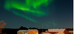
MFS is located 30 km to the south-west from Khanty-Mansiysk (100 000 inhabitants). Near the station, a limited number of local people, mostly from Khanty-Mansiysk town, can be met while fishing in the rivers and lakes. Hunting is mainly a winter activity using snowmobiles. The wider area is part of oil/gas extraction area, a newly built road to the oil extraction site goes around the station at a 3 km distance.
ACCESS
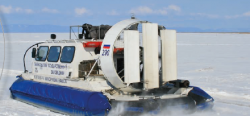
MFS is a remote station without road access. It is reached by different off-road vehicles or on foot depending on the season. There is a walking path (8 km long) going from the nearest road (highway Khanty-Mansiysk – Nyagan) to the station, which is used in the late summer and autumn. The season with high water lever (May-June) obstructs walking but opens the water transport facilities: it takes about 40 minutes to reach the station from Khanty-Mansiysk by boat. The snowmobile vehicles are used to visit the station in winter. The is also an all-terrain vehicle (Argo) for field work in remote areas. Access to the station: 1) by boat from the highway – 20 min, 2) by boat from Khanty-Mansiysk – 60 min, 3) on foot about 8 km, 2-3 hours, 4) by off-road vehicle and snowmobile – 30 min, 5) a new to-be constructed oilfield road.